Monday, October 4, 2010


By Marty Basch
Western Maine's Kezar Pond is often lost in the shadows of its big brother Kezar Lake to the north. That's okay for quiet water-loving paddlers searching for tranquility and scenery that is often found off the beaten path.
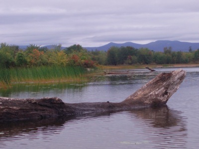
The pond is serene, particularly during the season of color when red rooted and green topped marsh grass frame a stage set with red maples, yellow birch, some oaks and ubiquitous pine. The western horizon is riddled with the notches and silhouettes of the White Mountains back in New Hampshire while the robust ridge of Pleasant Mountain stands tall to the southeast. There are a few local landmarks like Smarts and Knights Hills.
The destination is Fryeburg, the sleepy village that comes alive during summer weekends when hordes descend on the Saco River and for one week in October when the masses take over for the fair. The celebrated fair runs from October 3 to October 10 so paddling travelers should either be aware of the area's back roads or plan a trip after Columbus Day.
Though there are motorboats, the 1800-acre pond is a delightful precious pearl in the jewelry box of western Maine waterways. Reached off Hemlock Bridge Road (partly dirt) from Route 302 east of Fryeburg, the trip's onset contains two unique attributes: a covered bridge and a segment along the old course of the Saco River.
Paddling around the pond combined with the in-and-out on the river is an easy way to spend an autumn morning or afternoon.
A plaque by the handsome bridge tells the Paddleford truss styled link was constructed in 1857, but further research reveals the 136-foot span had a makeover in 1988. Listed on the National Register of Historic Places, there is parking available on both sides of the bridge as well as launches into the seemingly stagnant waterway.
Technically the paddling is upstream, but the current is rather weak. There is a sense of coolness and history to kayak underneath the bridge, imagining that gap-toothed farmers yelling commands once guided teams of muscled oxen hauling bales of hay or heavy loads of potatoes across the bridge now frequently by sport utility vehicles. There are tumbles of granite by the span, piers constructed to raise the bridge higher as a precaution against being washed away in floods.
Then there is the river, the curving long neck of a watery banjo that is Kezar Pond. For perhaps a mile, and certainly no more, the old course is the passageway with its downed trees looking like underwater skeletons, high muddy banks and even a dilapidated shack that would fall into the water if not for the trees. Across from that shack stands a good-looking country home with steps down to the water.
With the exception of a brief, narrow man-made rocky channel that funnels the placid water into a burst of quick water, the going is benign along the river that was abridged by a 19th century canal. It's a chance to watch the wind steal the leaves from the trees and see their final flight to water, land or perhaps the bow of a boat. Traveling geese in v-formation make their southern voyage overhead. Fishermen stroke by in canoes, hopeful for bass and perch.
The tapered river leads to a vast bowl ringed by mountains and hills. It would be nice to be able to write a bald eagle stood atop one of the trees like a sentinel as the kayak passed by. But it wasn't so. That happened a few years during a trip with some visiting friends from Texas who marveled at the bridge, stately bird and landscape. Instead, this time a heron flew overhead. Still, not too shabby.
Though it's natural to look up to see the sandy beach in the north and wonder if those stagnant objects in the distance are moose (alas, they are rocks and logs), along the marshy areas in the southeast are freshwater mussels on the sandy bottom as well as little coves to explore. A handful of camps dotted sections of shore, but there is plenty of real estate around to find a wilderness atmosphere reached off a joyous dirt road in rural northern New England.